


Shuto Expressway
Tōkyō’s Metropolitan, or Shuto, Expressway, also known as the Shutoko (a contraction of Shuto Kōsoku Dōro, 首都高速道, which means Metropolitan Fast Road, or Metropolitan Expressway), is a network of privately-operated limited-access toll roads spanning the metro area. If you’re curious, they have an English-language site, including a page with a downloadable map of the system.
For illustrative photos on the Metropolitan Expressway, see my Highway Scenery page.
Route number 6, the “Mukojima Route”, runs along the east bank of the Sumida river as an elevated highway, crossing the river at the south end at Hakozaki junction where it meets routes 7 (to the east) and 9 (to the south). At the north end it turns east following the “Old-Ayase river” (a 0.5 km canal between the Sumida and Arakawa rivers) and crosses the Arakawa river where it meets route C2 (which runs along the Arakawa) at Horikiri junction. I’ve taken the section of route 6 along the Sumida as the prototype for my elevated expressway. This section has three entrance/exits: 605 (Komagata) at the south end, 606/607 (Mukojima) midway and 609/610 Tsutsumidori at the north end.
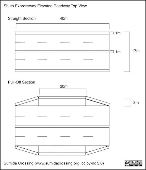
This part of the highway consists of two lanes in each direction with no breakdown lane. However, there are periodic pull-off areas for disabled vehicles. Measurements on Google Earth show the lane width to be between 3.0 and 3.5 meters (the typical expressway lane width in Tōkyō is 3.25m), and the typical overall width to be 17 meters. The extra 3m appears to be equally split between the central divider and the outer walls. The roadway is built in segments, with expansion joints where they meet, with a typical length of 38 to 40 meters. Spans can be longer, for example the span over the Chūō-Sōbu line bridge is 60m.
The pulloff areas are symmetric (there is one on both the northbound and southbound sides of the highway) and these occupy a typical 40m section, with a maximum width of 3m for each pull-off that extends 20m, with an angle at the ends. Dashed lane divider lines are 4m long and separated by 5.75m to 6m gaps. They aren’t necessarily painted in the same places on both sides of the highway, but often are.
Pulloff areas are equipped with emergency stairs leading down and under the highway (apparently allowing a connection between the two sides).
Light poles are arranged along the median at 30 m intervals, and are also located on the outside edge, but apparently only when ramps are present. Signposts are either small single poles mounted to the outside of the side barriers, or larger arches over the whole roadway, mounted to structures attached to the outside of the roadway. The only poles within the span of the roadway are the central light poles, located between the two guardrails in the median.
For modeling in N-scale, this equates to an overall width of 113mm (~4.5”) or 153mm (~6”) for the pull-off section, and section lengths of around 266mm (10.5”). Lane width will be about 22mm, and the edge and center median will be about 7mm (1/4”). I may vary that slightly to fit the constraints of my space, but that gives me a starting point for my design.
Note: while the outer sidewalls are often quite low, not any higher than the central guardrails, there are places with substantially higher walls or fencing, particularly above pedestrian areas and cross-streets.
Expressway Dimensions
