


Tōkyō River Scenery
Tōkyō is a port city, with several large rivers that drain the Kantō Plain flowing through it and into Tōkyō Bay. The banks of the rivers are typically walled with either earth or concrete, to keep low-lying parts of the city from flooding during storm surges or heavy rains. And river property is some of the only real estate that was relatively inexpensive to build above when highways and railways were constructed in the twentieth century, so they have an interesting layered look to them in places, with one structure over another in places. Here are some of the photos I used as inspiration for the scenery of my model railroad. It’s only a representative sampling of the ones I used, but it will hopefully give a feel for what effect I was striving for, and allow you to see how well I did.
Many other signs are available online, but all too often the photographer felt the need to copyright them. It’s still reasonable to use them to decorate a model railroad (that’s pretty obviously “fair use” under most versions of the law), but I won’t link any of those here.
Bridges and Parks
.jpg)
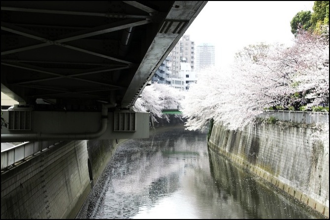
Sōbu railway bridge over the Sumida River
Photographer: Pieria
This is the Sōbu railway bridge over the Sumida River. Its deck just clears the levee wall on the far side of the river, likely making it about 7 meters above low tide level. This stretch of the Sumida is very urban, with simple concrete levees on both sides, and a paved walkway inside the levees. Further up the river, there is more greenery.

Sumida Park on the Sumida River, Asakusa, Tōkyō
Photographer: e97h0017
This is a park on the west bank of the Sumida River in Asakusa, slightly north of the Sōbu bridge. The bridge faintly visible at the upper left is the Tōbu Railway’s, which connects to elevated viaduct leading into Asakusa Station just to the south. It appears to be higher than the Sōbu railway bridge. Notice how the vegetation has overrun the concrete levee in the middle of the picture.
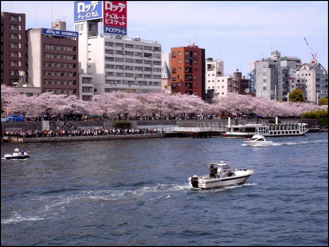
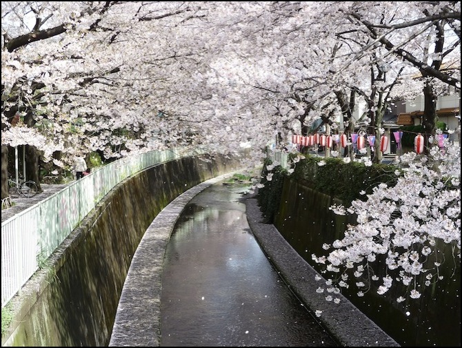
Cherry-blossom (Sakura) Season on the Sumida River
Photographer: Yoshikazu Takada
This park is slightly further south (notice the red billboard, which also appears in the distance in the preceding photograph). In the spring, the cherry blossoms bloom, and everyone comes out to look at them.

Azuma bridge and Shuto Expressway No. 6 on the bank of the Sumida river
Photographer: 663highland
Here’s a typically cluttered Sumida River scene, this one of the east bank. The red bridge is the Azuma bridge, which crosses just south of Asakusa Station (on the Tōbu Isesaki Line, the Toei Asakusa Line, and the Tōkyō Metro Ginza Line). The elevated expressway is the Shuto Expressway (more formally, Metropolitan Expressway #6, Mukojima Route). The building with the golden flame on it (the locals reportedly use a more scatological term for it) is the Asahi Beer company headquarters. On the right side of the photo, you can see a ramp leading down from street level to a paved walkway along the embankment. The west bank park picture above is a short ways upriver from here.
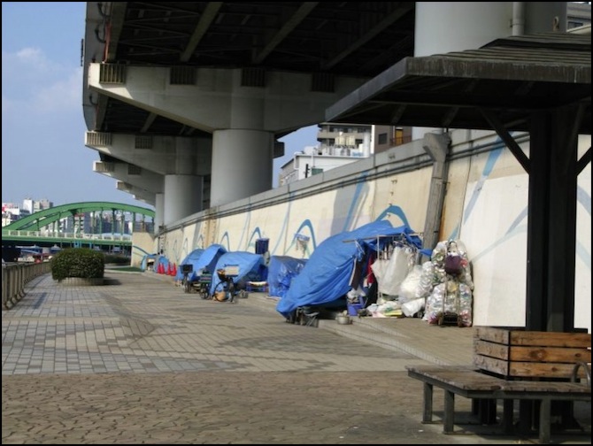
Homeless on the Sumida riverbank, under Metropolitan Expressway No. 6
Photographer: Moon Angel
Tokyo isn’t immune to homelessness, as this photo looking north at the Umaya bridge on Kasuga Avenue shows (the shelters here are underneath Metropolitan Expressway Number 6). The embankments of the Sumida (and other rivers) are home to many people using improvised shelters made with blue tarps.

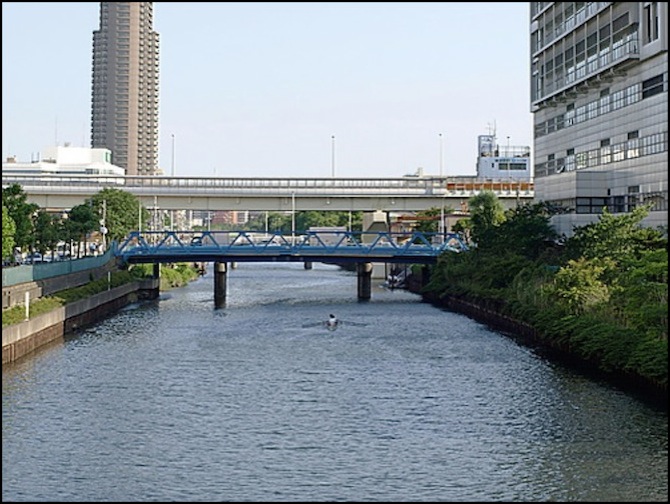
The Arakawa River
Photographer: LERK
This isn’t the Sumida River, it’s the nearby Arakawa River, and the Toei Shinjuku subway line bridge, but it gives a good visual of the effect I’d want to re-create with my bridges since it’s a truss bridge similar to the Kato model. The Arakawa is wider, so it makes the bridge look lower, but it’s clear that the bottom of the bridge is higher above the water than the top-to-bottom dimension of the bridge, though not by much. Although we’re still in urban Tōkyō, within the 23 wards, the land along the Arakawa has a wilder, less manicured, look to it. It’s all floodplain, but so are the more urbanized park embankments along the Sumida.
Canals and Drainage Channels
Tōkyō has many artificial waterways, some are smaller rivers that have been heavily walled due to the large amounts of water carried during storms. Others are canals from a more industrial era, when ships and barges moved between landfill islands or deeply into low-lying areas to reach industrial facilities. And some aren’t much more than open storm drains, although the probably follow the path of an historical stream. Today most of the land around them has shifted to residential, commercial or recreational uses (often all three in close proximity).
Yokojikken-gawa River in Sumida Ward, Tōkyō
Photographer: Leyline
This is the Yokojikken-gawa River (which is redundant, since “gawa” means river, but that’s how this one appears on the only map I could find that names it). It’s a canal that runs north-south in Sumida. This appears to be the view south from Keiyo Road (route 14); the elevated structure is Metropolitan Expressway number 7. The blue structure carries a pipeline of some kind over the river. The straight sides, of metal topped with concrete, are typical of many of these older industrial canals, which don’t have the same high-volume flow during storms that longer rivers do. The white building on the right is the Bokuto Hospital, located roughly on the site of a certain fictional police station of the same name.
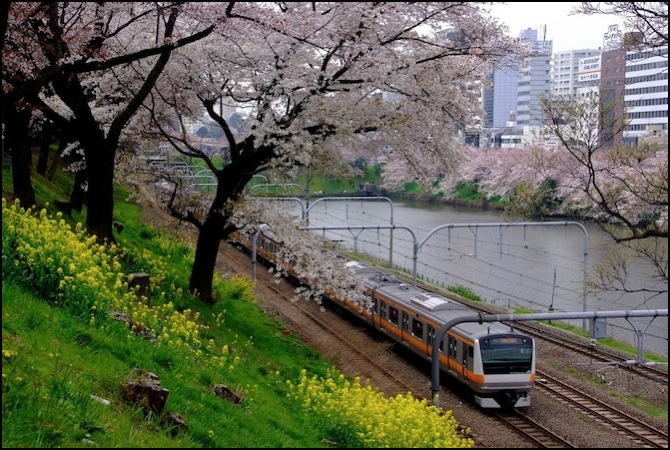
Chūō line along the Kanda River in Chiyoda, Tōkyō
Photographer: saitomo
This is a stretch where the Kanda river, which is underground in some places, and quite narrow in others, widens a bit. Along the south bank run the four tracks of the Chūō Rapid line and the Chūō-Sōbu line. Although technically a river it is not navigable (except for short stretches) and serves mainly as a drainage channel for the city. But the structure of the sides suggest the total flow is much less than in other areas.
Drainage channel in Kandagawa, Tōkyō
Photographer: kalleboo
Sometimes the channels are small, but quite deep to handle high volumes of water.
A larger channel
Photographer: OiMax
And sometimes they’re rather large. Note the escape ladder on the left and right sides (just loops of metal in the wall). This is supposedly in Edogawa, Tōkyō’s easternmost ward, but I can’t find any waterway there that looks like this.
